

Current Projects
Current Research Projects
HADES (Heloros Advanced Digital Exploration and Surveying)
Heloros (Italy)
The ancient Greek walled city of Heloros (ca. VIII century BCE – V century AD) is an endangered coastal cultural heritage site, which lies on a low hill along the Southeastern Sicilian shore, near Syracuse in Italy. Heloros is at risk due to rising sea levels and the increasing intensity of storms and coastal flooding. Today, Heloros’ beautiful coastal location leaves the remains of the city exposed to the threat of a projected sea-level rise of up to 25 cm by 2040-2050. These variations will complicate access to the Eloro beach, where several ancient structures are located and will further damage the site's ancient fortifications. Heloros was the first sub-colony of Syracuse and had enormous logistical importance in the Greek colonization of Eastern Sicily through its harbor, access to the nearby Tellaro river, and impenetrable fortifications.
Despite its long history, prowess, and cultural significance, Heloros is understudied and currently closed to the public due to looting issues at the site. Incredibly, its ancient harbor has never been found. However, this important Greek site is also affected by an even more insidious loss of knowledge due to the lack of publication and preservation of original notes, plans, photographs, and drawings of areas excavated in the twentieth century. This scarcity of attention is among the factors that determined a decreased awareness of the importance of Heloros among the nearby communities and limited funding for its preservation.
In 2022, the LMU Institute for Digital Cultural Heritage Studies joined a new research and digital preservation initiative at Heloros under the framework of a collaborative agreement between the Institute for Digital Exploration (IDEx) at the University of South Florida and the Parco Archaeologico di Eloro e Villa del Tellaro. This project aims at further investigating the cultural importance of Heloros, revalorize the archaeological site, and reframe a sense of urgency about its preservation to increase its resilience. The projects goal are: 1) identify, digitize, and analyze legacy data and material; 2) employ digital mapping and 3D exploration techniques to acquire new geospatial and 3D data at the site; and 3) utilize a dataification approach to create new knowledge from these new data through layered collection of natively digital and digitized legacy data. The project is characterized by a strong public-facing mission. The project results will be made available to the public and the academic community via an online digital collection of archaeological, geospatial, and 3D data. The project will also draw a digital baseline of Heloros to reconstruct the site in 3D for future public awareness campaigns based on Virtual Reality (VR) and Augmented Reality (AR) to be developed in collaboration with the Paolo Orsi Archaeological Museum of Siracusa.
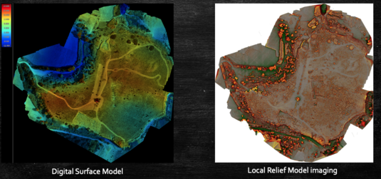
The 3D exploration of Heloros and adjacent territory, including the extremely important site of the Roman Villa del Tellaro, employ the latest in airborne and terrestrial laser scanning, digital photogrammetry, and ground-penetrating radar mapping to survey the entire ancient city and shed light on its urban structure and hidden architectural features and neighborhoods through digital exploration and spatial analysis in GIS. The project also experiments Machine Learning techniques for automated data analysis and classification to monitor the site and understand the impact of sea-level rise and the magnitude of looting.
Finally, the project will engage with the theoretical and practical approaches needed to understand the proper use and re-use, management, curation, and integration of the digital and archaeological data collected by the team.
Palenque Regional Project (Mexico)
The purpose of this project is to define a new approach to the study and preservation of Maya archaeological heritage that is able to promote digital documentation methods of heritage sites and disseminate results in under-documented areas of Southern Mexico.
To achieve these goals, we have a partnership with the Proyecto Regional Palenque (Palenque Regional Project- PREP), developed by Dr. Rodrigo Liendo Stuardo of the National Autonomous University of Mexico (UNAM), where also UC Berkeley is collaborating.
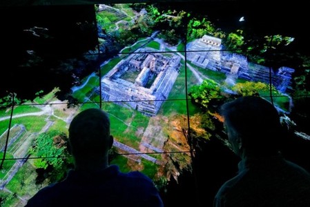
The project also experiments with new methodologies of online data curation and dissemination based on open access, 3D visualization, and high-speed networks. Thus, the project uses the Pacific Research Platform (PRP), the new UC big data freeway system, to share and co-locate Big Cultural Heritage Data (BCHD) over this high-speed network to be distributed in state-of-the-art 3D visualization platforms.
The project explores alternative means of dissemination for visitors and local communities in Chiapas based on augmented reality and mobile apps. Mobile technologies will make 3D models, maps, and archaeological interpretations available to the public and local communities visiting Palenque simply by downloading a custom-made mobile app. Using this mobile app, visitors and local communities will be able to locate and scan target images placed in pre-determined points of interests and access a version of the database customized for the general public.
Media: Pointcloud Palenque